2013年1月28日月曜日

week5:topic is The bits of knowledge of thunder.

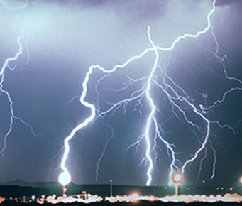
I think Thunder is dreadful! But if you know this, you become less fearful. I investigated about thunder.

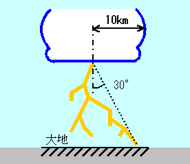
Range from which thunder falls
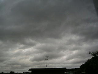
The width of a thundercloud is usually 10 km or less in radius. Electric discharge takes place in all the ranges of this thundercloud. Therefore, although thunder will fall to somewhere in this range, it cannot be predicted where it falls.


A safe place

Aren't you fearful, when you are outside and thunder begins to sound? There are safe places at such time.

① in the car


Since thunder is electricity, it chooses the substance in which it is easy to flow through electricity. If it falls to the thing made with metal, such as a car, a train, and Buss, it will be through to the metal and will escape on the ground through a tire etc. But you do not touch metal.
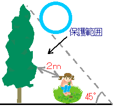
②near a high things 
Thunder has the character to fall at a high place. It is important to take refuge near the high things, such as a tree, a building, a telegraph pole. There is no high thing in the neighborhood, and when you are the highest, the possibility of a "direct stroke" becomes high. The range of a safe place is about 45 degrees from tops, such as a building. This is called "scope of protection." If a high thing is approached too much even if it is in scope of protection, the thunder which fell to the high thing may fly and move to man. This is called "side stroke."


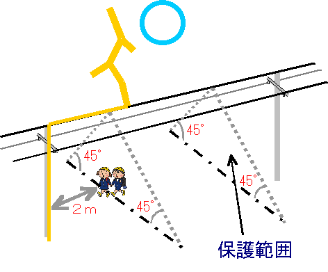
③Under an electric wire

When there is no building which enters immediately close easily, the bottom of an electric wire is good. It takes refuge into a safer building, moving within the limits of it, since there is 45-degree scope of protection also from a telegraph pole or an electric wire. Don't touch a telegraph pole. And please be 2 m or more away.


However, these places are outsides and it cannot be said that it is safe. 
Blaming in a safe building is the best.
Then, other bits of knowledge...

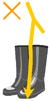
*High rubber boots are almost meaningless.
Voltage of thunder is very high .So It becomes impossible to insulate by the thing called insulator in everyday life.
 
*Dangerous also indoors
Lightning current may enter from the antenna and telephone line of television.
There is an example which died on the telephone.

 
*Water is dangerous.
The electricity of thunder escapes on the ground by thunderbolt. It will become a high voltage, if a thunderbolt is close when the water pipe and the water pipe are made of metal. Therefore, probably, it will be better to be 1 m or more away from a thing connected to these.

 
*Even if it does not rain, thunder falls.
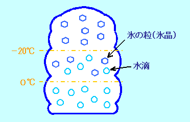
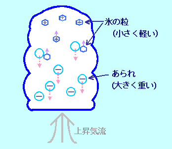
If electricity accumulates in clouds, thunder will occur. The particles of the clouds which become the base of raindrops have a mechanism of generating electricity. So thunder may come down earlier than rain.
While playing tennis, the accident has actually happened. Although the sound of thunder could be heard in the distance and it was not raining, the racket flung up in order to serve was struck by lightning.


If thunder comes to the neighborhood, let's will be careful!!!


2013年1月22日火曜日


week4:Topic is structure of thunder


Why is thunder made?
Although it is clear that it can do in clouds, thunder has not occurred in every cloud. Thunder occurs or does not occur. The base of thunder is static electricity. If a thing rubs, static electricity may occur. When getting off a car on the day which winter dried, clothing and a chair rub, and just before touching a door, it may spark." clouds are the same as this. The particles of clouds rub and static electricity occurs. If it rubs violently, thunder will occur.


The size of raindrops is 0.2 mm. The particles of clouds are diameters and are about 1/100 of that.
And volume is about 1/1 million size. Although the fall is carried out with gravity, since it is small, a drag of air is strong considering the size, and falls very slowly at it. Since the sky is low-temperature, the particles of clouds may be waterdrop, but it may be ice.Since at least 0 ℃ or less does not freeze easily in the air for the surface tension of water, it becomes water drop. However, in the case of about -20 ℃ or less, it is ice generally. In the cumulonimbus of summer, even if there is 30 ℃ near surface of the earth, the sky is very low-temperature. The cumulonimbus top is also -50 ℃. The tops are icy particles although the bottom of clouds is water drop.


It is same that icy particles and frost of a freezer are made. And the water vapor of the air changes to a solid directly. Since gaseous vapor can be moved quite more quickly than the water drop of a liquid, vapor adheres to ice rapidly and icy particles can grow quickly. And it is going to become heavy and is going to fall.However, when surface of the earth can warm by solar radiation and there is a strong ascending current, it is raised and does not fall easily. While going up in clouds or having fallen, it becomes still larger and becomes large hail. Since the icy particles and hail from which a size is different differ also in in fall velocity, they repeat a collision mutually. "Rubbing" happens then and static electricity occurs. When it collides, an electron is made from one particle. At this time, small particles (cryohydrate) become positive charge, and big particles (hail) become a minus electric charge. Why do big particles become a minus electric charge? It is not solved. Since the big particles are heavier, it moves to the direction under clouds and small particles move to the direction on clouds by an ascending current. Therefore, in the direction under clouds, the electric charge of minus and the electric charges of plus in the direction on clouds gather. Moreover, positive charge is guided with the minus electric charge gathering in a cloud base on the ground. This is called "electrostatic induction."


I was surprised that particles are rubbing in clouds!


2013年1月7日月曜日

week3


week3: topic is types of clouds2
 
Although I wrote the blog about the kind of clouds divided internationally,
 I would like to introduce various kinds of clouds this week.
I looked for the picture of the interesting clouds investigated on the Internet.
They are the clouds photographed not only Japan but all over the world.
Then, let's see interesting clouds1!!
 
At first  they are the clouds which can be seen  in Japan.
 

 Roll-like clouds.
Seemingly it will appear, when the strong convection has taken place under clouds,
 and it will become heavy rain in many cases.


Hole vacancy clouds
It may evaporate, if the waterdrop in altocumulus serves as an icy crystal, becomes heavy and falls.
Then, the altocumulus of the portion is lost and will be opened by the hole behind clouds.
It seems that seeing is quite rare even if it is small hole vacancy clouds.

Umbrella clouds
It is a kind of a lenticular cloud made to near [ the ground ] ?15000 meter height.
if a lenticular cloud is made at the peak of a mountain.
I think it is visible like an umbrella. So it is colled "kasagumo" in jupan.


Waterfall clouds
If the clouds which occurred in the mountain overcome the ridgeline of a mountain and fall along with a surface of a mountain, it is so called from it being visible like a waterfall.

Jellyfish clouds
Literally, they are clouds like jellyfish.
The cloud top has a form of a round dome and the cloud base is disturbed by turbulence.
Although it can see also on the flat ground, beautiful jellyfish clouds are seen in a mountain slope in many cases.
This is lovely


. Sea of clouds
A mountain slope etc. are the things in the state where fog occurred in the wide range
 by radiative cooling.
This situation can be seen the time of climbing a mountain,
 and ride on the airplane.
I want to climb Mt. Fuji and to see this view.


Feather clouds 
Although it is a kind of cirrus, since it is visible like the feather of a bird,
 they are the clouds currently called feather clouds.

Veil clouds
The thing of the clouds which spread thinly horizontally on the cloud top made to the height like near [ the ground ] ~16000 meter is said.
It will be called hood clouds if a scale is small.

Next clouds is still more rarely!!!!!


Wax and clouds
Breast clouds grow and it says the thing of the clouds which whirled around.
Depending on the case, it becomes a tornado


 Breast clouds
The thing of the clouds in the state where many wen-like clouds droop from the bottom of clouds made to a height of 15000 meters is put.
In the United States, if made in the place where this cloud is low,
it is considered as the sign of the tornado.
.I was surprised for this cloud to be very powerful!
 
 
クリックすると新しいウィンドウで開きます
Iridescent clouds
The edge of the clouds near the sun is a phenomenon which is divided into the color of a spectrum, colors beautifully and is in sight.
There is also a district regarded as an auspicious phenomenon.
It is beautiful just like a rainbow.
 
Morning glory clouds
The belt of the clouds of the shape of a huge roll.
The thing of northern Australia is famous and length is if it amounts to a maximum of 1000 km.
Were there many interesting clouds?
It wondered why it would become that form.
The clouds from which an each form differs.
Even if it has been seeing it, it does not get bored.
If such clouds are on my head, I will be excited very much.
I would like to look at new clouds by my own eyes very much!!
When you are free, please look up at sky and see clouds.
And please find your favorite clouds.

week2


week2: topic is types of clouds
 
Various clouds are visible to the sky.  
Do you know how to divide clouds?
I did not know it. So I investigated at the internet.
 
The kind of clouds are divided with the altitude.
And clouds are divided into 10types in the form.
An altitude is 0m~10000m Then! it introduce one by one.
 
No.1  cirrus
The clouds made in the highest place in clouds.
It seens to have swept by brush and the tip of clouds has sometime often bent in the shape of a key.
It is felt very coolly and beautiful.

 
No.2  cirrocumulus
This clouds made of many small grains.
It seem to have scattered the mackerel, it is called the cirrocumulus.
A form collapses easily and it does not stop a beautiful figure for a long time in many cases.


No.3  cirrosratut
It is also called haze clouds and there is this cloud,
halo may be made around the sun or the moon. 


No.1~3 are made among about 9000~10000m
 These clouds are made of small ice.

 
No.4  altocumulus
It looks also like the group of the sheep.
Since each clouds are large and thicker than cirrocumulus, the shadow of thin gray is made at the bottom of clouds.
this cloud is about 6000m

 
No.5 altostratus
This cloud covers sky to thin gray or milk white.
Through this cloud, the sun seems to have let ground glass pass.
 
 
No.6  nimbostratus
Since long time rain is showered on, it is called "rain cloud"
The season of autumn rain when the leading role's rain is long and this cloud continues comes on from the middle of the month in September to the beginning of October.

No. 5~6 is about 4000~5000m
 
 
No.7  cumulus
The representative case of clouds!
It is visible to the cotton candy which seems to be delicious.


No.8  stratocumulus
The feature of this cloud is that the clouds of shape of a slightly thickerlump have gathered without a creuce. 
The day of almost all cloudy weather is this cloud.
 
 
No.9 stratus
This is the clouds made in the lowest plane in clouds.
Surface of the earth is touched in many cases, and if it is a little slightly elevated mountain,
 it will cover so that the whole may be hidden.
It may be this cloud if we look at mountain fog from a distance.

No.9 is 0~1000m
 
No.10  cumulonimbus cloud
 
Since it is highly tick, if this cloud comes on the head.
It becomes derk like dowm the sun and the rain of a large drop will fall.
This is the clouds which become thunder with hail and hail.
It is 1000~5000m
 
 
They has been classifide into 10types
 by the international clinate confedence( International Cloud Atlas ) !! 
I was surprised that the kind of clouds is worldwide and is classified similarly.
And since clouds differed in the form greatly with the altitude, they regarded me as interesting.
The next week wants to introduce the unusual clouds.  


巻雲 ( Cirrus )、巻積雲 ( Cirrocumulus )、巻層雲 ( Cirrostratus ) の 3 種類に、中層雲を高積雲 ( Altocumulus )、高層雲 ( Altostratus )、乱層雲 ( Nimbostratus ) の 3 種類に、下層雲を層積雲 ( Stratocumulus )、層雲 ( Stratus )、積雲 ( Cumulus )、積乱雲 ( Cumulonimbus )